
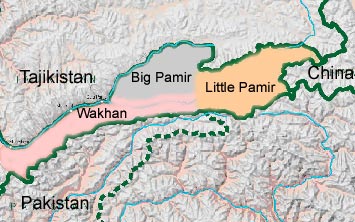
The Wakhan is a narrow panhandle of valleys and high
mountains that stretches eastward from the province of Badakhshan in
northeastern Afghanistan following the head waters of the Amu Daria to its
sources in the Pamir mountains.
- It borders Tajikistan to the north, Pakistan
to the south, and China to the east.
- The corridor is widest (65 km) in the middle, where it
includes the Nicholas Range; it is narrowest along its western third,
where the width is 13-25 km except for a breadth of 30 km at the
headwaters of the north-flowing Ishtragh River. At the western entrance,
the corridor is 18 km wide.
- The Wakhan was established as an imperial buffer zone
between the Russian and British empires in the late 19th century.
- The Wakhan and Pamir are an area of unique interest both
from the point of view of its natural environment and biodiversity as well
as its human population of settled Wakhi farmers and transhumance herders,
the yurt-dwelling Kirghiz.
- The corridor was a political creation
of the Great Game. On the corridor's north side, agreements
between Britain and Russia in 1873 and between Britain
and Afghanistan in 1893 effectively split the historic area of Wakhan by
making the Panj and Pamir Rivers the border between
Afghanistan and the Russian Empire.
- On its south side, the Durand
Line agreement of 1893 marked the boundary between British
India and Afghanistan.
- This left a narrow strip of land as a buffer between the
two empires, which became known as the Wakhan Corridor in the 20th
century. The corridor has 12,000 inhabitants.
**********************************************************************************************************************************